Like houses and buildings, the names of streets and lanes around the village have changed and evolved over time; where possible we have included all the names that we know to date. Names are most often linked to family names or the purpose of the location but their fluid nature often complicates family and local history searches – if you are able to add to our knowledge, we would like to hear from you.
“The village lied in a miry part of the county and consists of about 70 dwellings; the roads to it are intolerable in the winter. The road from the Fosse to the village is in a right line, very spacious, at the distance of about half a mile. The village, or rather the lanes leading to it, are a labyrinth, the way I entered it. The numerous passages, open to the more numerous inclosures adjoining the village, misguide you: the trees in the hedgerows are lofty, many and meet each other, which made the passages gloomy and miry, and some them almost impassable.”
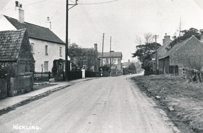
More work is needed to confirm dates but originally this road would have been just one of several muddy tracks leading into the village; only relatively recently did it become the main route into the village. It is understood that ‘Bridegate’ has consistently referred to the ‘top end’ of the lane leading to Hickling Pastures whilst the ‘bottom end’ where it joins Main Street in Hickling has had a series of different names including Chapel Lane and Smithfield Lane – it is possible that these were colloquial in nature rather than formal but these names do appear in official records at times, too.
The 1774 Enclosure Map doesn’t name the road at the village end but half way along it is clearly labelled as ‘Bridegate Road’.
The 1910 Finance Act Map labels the whole road as ‘Bridegate Lane’.
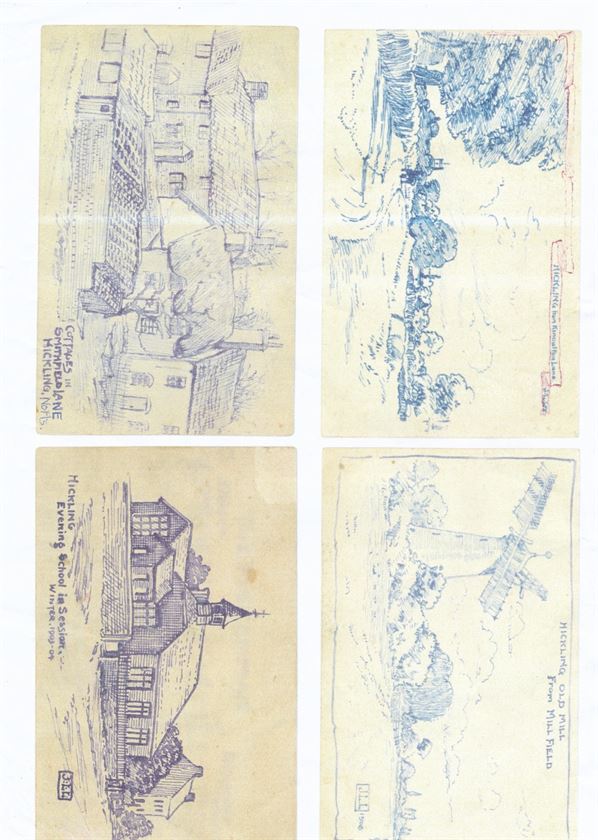
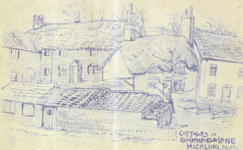
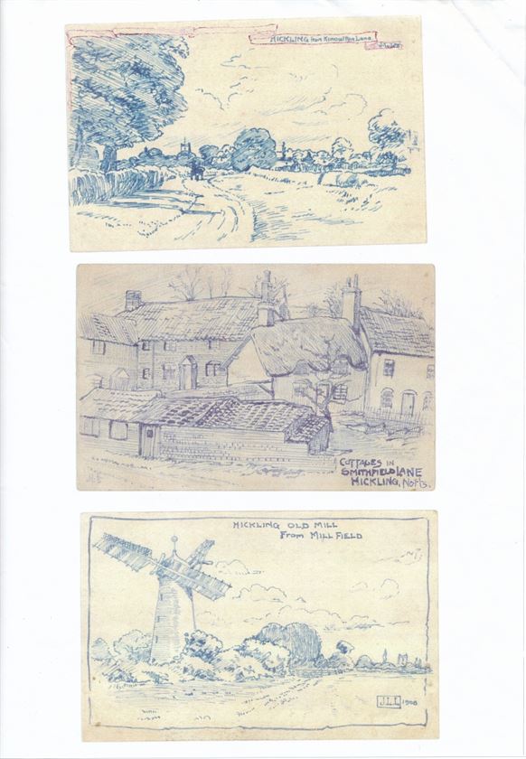
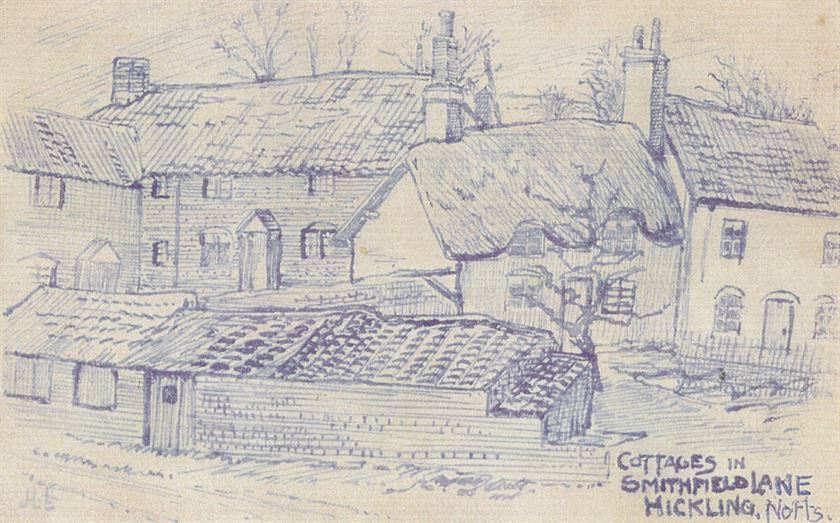
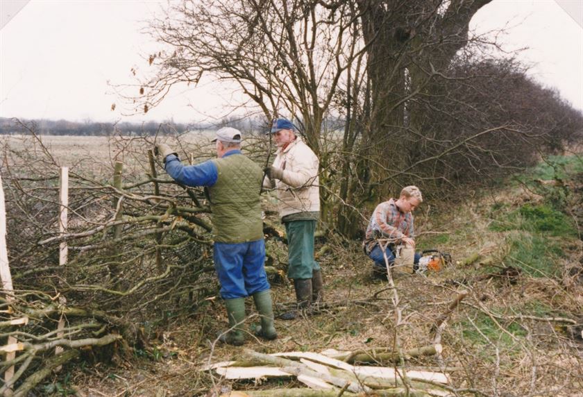
In 1905 the headmaster Mr Laws labelled a sketch of the cottages at the village end of the lane, ‘Smithfield Lane’.
1911 Census (superficial search): 5 households are listed on Bridegate Lane (no house names) and 1 household on Smithfield Lane (no references to ‘Chapel Lane’).
Photographs in the Wadkin Archive from the 1930s refer to ‘Chapel Lane’.
1939 Register; households are listed on Chapel Lane but there are no references to Bridegate Lane and just one reference to the Cook family at Bridgate Lodge, The Pastures.
1910 Finance Act Map clearly labelled as ‘Bridegate Lane’
At some point the name ‘Bridegate Lane’ was formalised for the full length of the road again but pinning down the exact dates for shifts in the name is difficult; changes would have happened gradually with some cross-over and habit may mean photographs and references were labelled ‘traditionally’ rather than according to the common usage at any particular time.
At present, it seems that ‘Smithfield Lane’ pre-dates ‘Chapel Lane’; a sketch by the headmaster Mr Laws in 1905 is labelled ‘Smithfield Lane’ and references in the 1930s use the name ‘Chapel Lane’. The origin of the name ‘Bridegate’ isn’t yet known but it was in use at the time of the 1774 Enclosure:
‘Bridegate’ may be a corruption of ‘Bridgegate’ but there is no obvious watercourse that might link to such a name; the word ‘bridge’ developed from the Middle English ‘bryg/brig/brigh’ meaning the adjustment to ‘Bride’ would be relatively late.
Another possibility could be ‘Bride Gate’ but all other references to this phrase relate to weddings.
Brid/Bryd/Bridd: possible Anglo-Saxon derivation meaning ‘young bird’ (Old English; for example, John Wycliffe in his bible translation of c.1395).
‘Bride’; Middle English derivation meaning ‘Bridle’ and linking to horses and riding.
We would be grateful to hear from anyone who could help with this name origin.
W0075 Chestnut Farm (1920s)
W0075 Chestnut Farm (1920s)
W0075a Chestnut Farm (1920s)
W0075a Chestnut Farm (1920s)
W0075aa Chestnut Farm (1920s)
W0075aa Chestnut Farm (1920s)
W0075b Chestnut Farm (1920s)
W0075b Chestnut Farm (1920s)
W0075bb Chestnut Farm (1920s)
W0075bb Chestnut Farm (1920s)
W0081 Flooding: W0081 to W0107
W0081 Flooding: W0081 to W0107
W0088 Flooding - Main St 1975
W0088 Flooding - Main St 1975
W0088a Flooding - Main St 1975
W0088a Flooding - Main St 1975
W0088b Flooding - Main St 1975
W0088b Flooding - Main St 1975
W0088c Flooding - Main St 1975
W0088c Flooding - Main St 1975
W0088d Flooding - Main St 1975
W0088d Flooding - Main St 1975
W0089 Flooding - Bridegate Lane 2001
W0089 Flooding - Bridegate Lane 2001
W0089a Flooding - Bridegate Lane 2001
W0089a Flooding - Bridegate Lane 2001
W0089aa Flooding - Bridegate Lane 2001
W0089aa Flooding - Bridegate Lane 2001
W0089b Flooding - Bridegate Lane 2001
W0089b Flooding - Bridegate Lane 2001
W0089bb Flooding - Bridegate Lane 2001
W0089bb Flooding - Bridegate Lane 2001
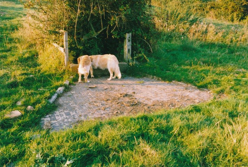
W0114 Washpit/Weir site Bridegate Lane
W0114 Washpit/Weir site Bridegate Lane
W0114aa Washpit/Weir site Bridegate Lane
W0114aa Washpit/Weir site Bridegate Lane
W0114 site of the old Washpit/Weir on Bridgeate Lane
W0114 site of the old Washpit/Weir on Bridgeate Lane
W0114aa site of the old Washpit/Weir on Bridgeate Lane
W0114aa site of the old Washpit/Weir on Bridgeate Lane
Clawson Lane is the main route out of Hickling into the Vale of Belvoir; other roads/routes either ascend or skirt the escarpment. Until the C19th Long Clawson was known as ‘Claxton’ (probable Anglo-Saxon origins). On the 1774 Enclosure Map it is marked as ‘Long Claxton Road’.
W0076 Clawson Lane (May 2006)
W0076 Clawson Lane (May 2006)
W0076a Clawson Lane (May 2006)
W0076a Clawson Lane (May 2006)
W0080 Snow 1979
W0080 Snow 1979
W0080a Snow 1979
W0080a Snow 1979
W0080aa Snow 1979
W0080aa Snow 1979
W0080b Snow 1979
W0080b Snow 1979
W0080bb Snow 1979
W0080bb Snow 1979
W0081 Flooding: W0081 to W0107
W0081 Flooding: W0081 to W0107
W0090 Flooding - Dalby Brook bridge pre-1922
W0090 Flooding - Dalby Brook bridge pre-1922
W0090a Flooding - Dalby Brook bridge pre-1922
W0090a Flooding - Dalby Brook bridge pre-1922
W0090aa Flooding - Dalby Brook bridge pre-1922
W0090aa Flooding - Dalby Brook bridge pre-1922
W0091 Flooding - Dalby Brook 1922
W0091 Flooding - Dalby Brook 1922
W0091a Flooding - Dalby Brook 1922
W0091a Flooding - Dalby Brook 1922
W0091aa Flooding - Dalby Brook 1922
W0091aa Flooding - Dalby Brook 1922
W0091b Flooding - Dalby Brook 1922
W0091b Flooding - Dalby Brook 1922
W0091bb Flooding - Dalby Brook 1922
W0091bb Flooding - Dalby Brook 1922
W0104 Flooding - Dalby Brook & Waterlane Farm
W0104 Flooding - Dalby Brook & Waterlane Farm
W0104a Flooding - Dalby Brook & Waterlane Farm
W0104a Flooding - Dalby Brook & Waterlane Farm
W0104b Flooding - Dalby Brook & Waterlane Farm
W0104b Flooding - Dalby Brook & Waterlane Farm
W0105 Flooding - Clawson Lane aftermath 2001
W0105 Flooding - Clawson Lane aftermath 2001
W0105a Flooding - Clawson Lane aftermath 2001
W0105a Flooding - Clawson Lane aftermath 2001
W0105aa Flooding - Clawson Lane aftermath 2001
W0105aa Flooding - Clawson Lane aftermath 2001
W0106 Flooding - Clawson Lane 1998
W0106 Flooding - Clawson Lane 1998
W0106a Flooding - Clawson Lane 1998
W0106a Flooding - Clawson Lane 1998
W0134 new house on Home Farm woodyard (2005)
W0134 new house on Home Farm woodyard (2005)
W0134a new house on Home Farm woodyard (2005)
W0134a new house on Home Farm woodyard (2005)
W0135 Main St. between Marsh's Paddock and Clawson Lane (2005)
W0135 Main St. between Marsh's Paddock and Clawson Lane (2005)
W0135a Main St. between Marsh's Paddock and Clawson Lane (2005)
W0135a Main St. between Marsh's Paddock and Clawson Lane (2005)
W0135aa Main St. between Marsh's Paddock and Clawson Lane (2005)
W0135aa Main St. between Marsh's Paddock and Clawson Lane (2005)
W0135b Main St. between Marsh's Paddock and Clawson Lane (2005)
W0135b Main St. between Marsh's Paddock and Clawson Lane (2005)
W0136 Clawson Lane (2006)
W0136 Clawson Lane (2006)
W0136b Clawson Lane (2006)
W0136b Clawson Lane (2006)
W0136a Clawson Lane (2006)
W0136a Clawson Lane (2006)
W0137 Clawson Lane junction (1964 & 2006)
W0137 Clawson Lane junction (1964 & 2006)
W0137a Clawson Lane junction (1964)
W0137a Clawson Lane junction (1964)
W0137b Clawson Lane junction (2006)
W0137b Clawson Lane junction (2006)
W0138 Clawson Lane junction (1920s & 2005)
W0138 Clawson Lane junction (1920s & 2005)
W0138a Clawson Lane junction (1920s)
W0138a Clawson Lane junction (1920s)
W0138aa Clawson Lane junction (1920s)
W0138aa Clawson Lane junction (1920s)
W0138b Clawson Lane junction (2005)
W0138b Clawson Lane junction (2005)
W0138bb Clawson Lane junction (2005)
W0138bb Clawson Lane junction (2005)
W0153 sport, seats, allotments, farming & water
W0153 sport, seats, allotments, farming & water
W0179a Wartime in Hickling WWI & WWII
W0179a Wartime in Hickling WWI & WWII
W0179b Wartime in Hickling WWI & WWII
W0179b Wartime in Hickling WWI & WWII
W0240 Dalby Brook Bridge before being rebuilt (1987)
W0240 Dalby Brook Bridge before being rebuilt (1987)
W0240a Dalby Brook Bridge before being rebuilt (1987)
W0240a Dalby Brook Bridge before being rebuilt (1987)
W0240aa Dalby Brook Bridge before being rebuilt (1987)
W0240aa Dalby Brook Bridge before being rebuilt (1987)
W0240b Dalby Brook Bridge before being rebuilt (1987)
W0240b Dalby Brook Bridge before being rebuilt (1987)
W0240bb Dalby Brook Bridge before being rebuilt (1987)
W0240bb Dalby Brook Bridge before being rebuilt (1987)
W0242a&b Dalby Brook bridge rebuilt Feb 1985
W0242a&b Dalby Brook bridge rebuilt Feb 1985
W0242a Dalby Brook bridge rebuilt Feb 1985
W0242a Dalby Brook bridge rebuilt Feb 1985
W0242aa Dalby Brook bridge rebuilt Feb 1985
W0242aa Dalby Brook bridge rebuilt Feb 1985
W0242aabbcc Dalby Brook bridge rebuilt Feb 1985
W0242aabbcc Dalby Brook bridge rebuilt Feb 1985
W0242b Dalby Brook bridge rebuilt Feb 1985
W0242b Dalby Brook bridge rebuilt Feb 1985
W0242bb Dalby Brook bridge rebuilt Feb 1985
W0242bb Dalby Brook bridge rebuilt Feb 1985
W0242c Dalby Brook bridge rebuilt Feb 1985
W0242c Dalby Brook bridge rebuilt Feb 1985
W0242cc Dalby Brook bridge rebuilt Feb 1985
W0242cc Dalby Brook bridge rebuilt Feb 1985
W0242ccc Dalby Brook bridge rebuilt Feb 1985
W0242ccc Dalby Brook bridge rebuilt Feb 1985
W0256 new main sewers being laid 1993
W0256 new main sewers being laid 1993
W0256a new main sewers being laid 1993
W0256a new main sewers being laid 1993
W0256aa new main sewers being laid 1993
W0256aa new main sewers being laid 1993
W0256b new main sewers being laid 1993
W0256b new main sewers being laid 1993
W0256bb new main sewers being laid 1993
W0256bb new main sewers being laid 1993
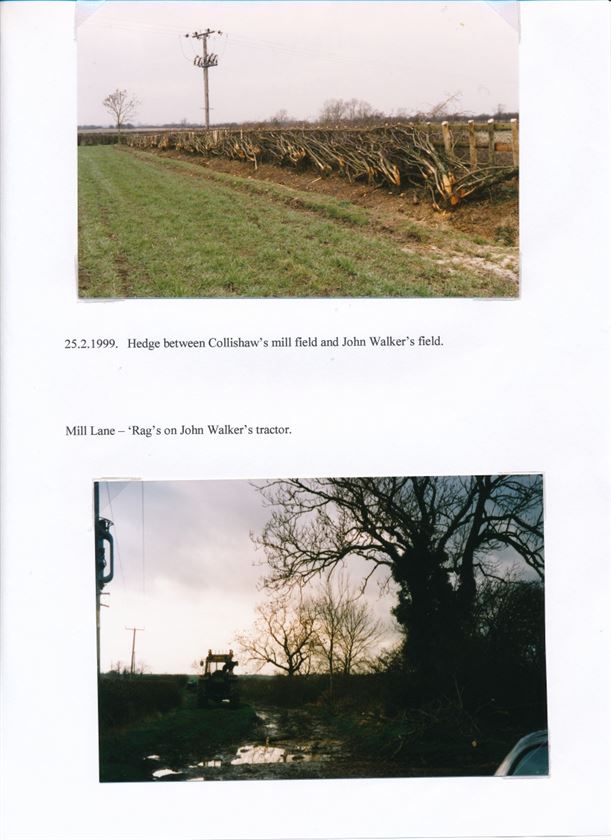
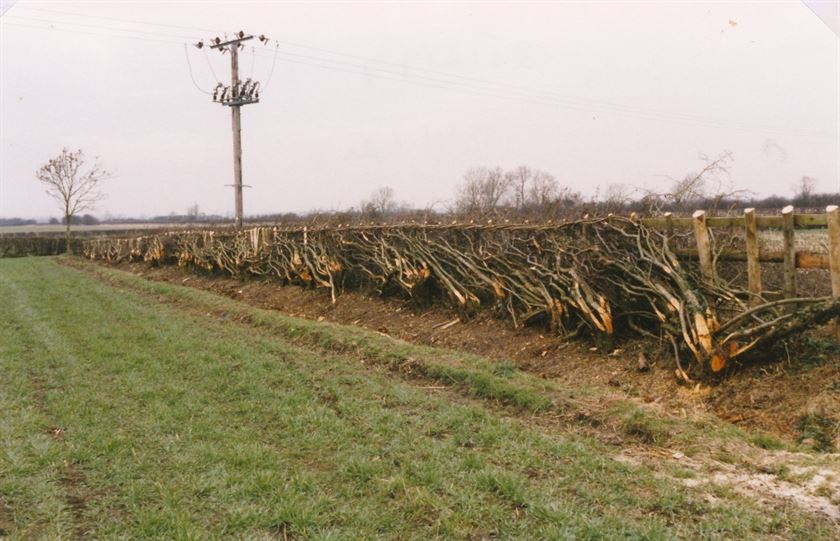
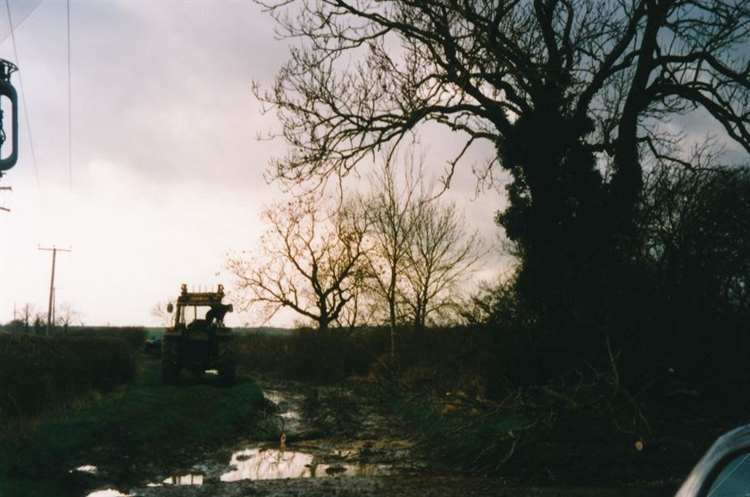
W0405 Wadkin, Walker, Collishaw 2002
W0405 Wadkin, Walker, Collishaw 2002
W0405a Wadkin, Walker, Collishaw 2002
W0405a Wadkin, Walker, Collishaw 2002
W0405aa Wadkin, Walker, Collishaw 2002
W0405aa Wadkin, Walker, Collishaw 2002
W0510 Gale damage 20th Oct 2000
W0510 Gale damage 20th Oct 2000
W0510a Gale damage 20th Oct 2000
W0510a Gale damage 20th Oct 2000
W0510aa Gale damage 20th Oct 2000
W0510aa Gale damage 20th Oct 2000
W0666 Dalby Brook flooding 1922
W0666 Dalby Brook flooding 1922
W0666a Dalby Brook flooding 1922
W0666a Dalby Brook flooding 1922
W0667 Dalby Brook flooding 1922
W0667 Dalby Brook flooding 1922
W0776 Lists of 'lane lettings for grazing' 1902 to 1929
W0776 Lists of 'lane lettings for grazing' 1902 to 1929
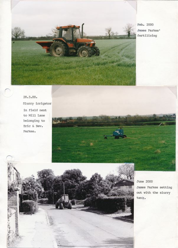
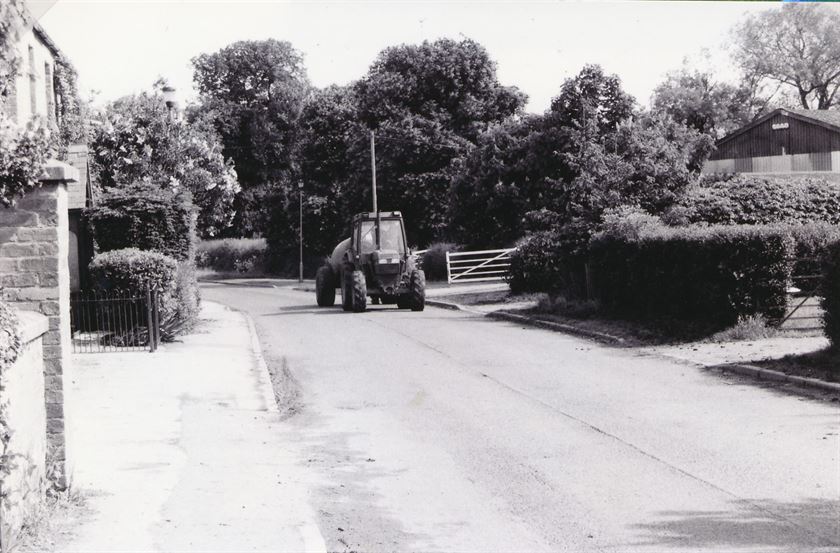
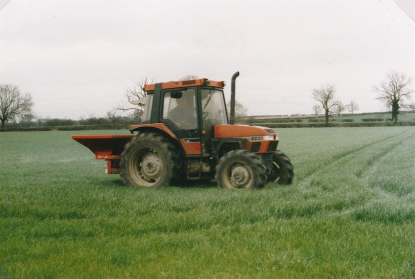
W0796 slurry spreading 2004
W0796 slurry spreading 2004
W0796a slurry spreading 2004
W0796a slurry spreading 2004
W0796aa slurry spreading 2004
W0796aa slurry spreading 2004
W0828 Sheep, Clawson Lane 2001
W0828 Sheep, Clawson Lane 2001
W0828a Sheep, Clawson Lane 2001
W0828a Sheep, Clawson Lane 2001
W0828aa Sheep, Clawson Lane 2001
W0828aa Sheep, Clawson Lane 2001
W0855 Mare & Foal Clawson Lane paddock 1999
W0855 Mare & Foal Clawson Lane paddock 1999
W0855a Mare & Foal Clawson Lane paddock 1999
W0855a Mare & Foal Clawson Lane paddock 1999
W0855aa Mare & Foal Clawson Lane paddock 1999
W0855aa Mare & Foal Clawson Lane paddock 1999
W0855b Mare & Foal Clawson Lane paddock 1999
W0855b Mare & Foal Clawson Lane paddock 1999
W0855bb Mare & Foal Clawson Lane paddock 1999
W0855bb Mare & Foal Clawson Lane paddock 1999
W0856 hay spoiled by bad weather 1988
W0856 hay spoiled by bad weather 1988
W0856a hay spoiled by bad weather 1988
W0856a hay spoiled by bad weather 1988
W0856aa hay spoiled by bad weather 1988
W0856aa hay spoiled by bad weather 1988
W0856b hay spoiled by bad weather 1988
W0856b hay spoiled by bad weather 1988
W0856bb hay spoiled by bad weather 1988
W0856bb hay spoiled by bad weather 1988
W0875 Faulks' contractors field opposite Clawson Lane & bordering Bridegate 1988
W0875 Faulks' contractors field opposite Clawson Lane & bordering Bridegate 1988
W0875a Faulks' contractors field opposite Clawson Lane & bordering Bridegate 1988
W0875a Faulks' contractors field opposite Clawson Lane & bordering Bridegate 1988
W0875aa Faulks' contractors field opposite Clawson Lane & bordering Bridegate 1988
W0875aa Faulks' contractors field opposite Clawson Lane & bordering Bridegate 1988
W0875b Faulks' contractors field opposite Clawson Lane & bordering Bridegate 1988
W0875b Faulks' contractors field opposite Clawson Lane & bordering Bridegate 1988
W0875bb Faulks' contractors field opposite Clawson Lane & bordering Bridegate 1988
W0875bb Faulks' contractors field opposite Clawson Lane & bordering Bridegate 1988
W0963 Cemetery creation 1955
W0963 Cemetery creation 1955
W1077a Featherstone Indentures & Wills (land around Clawson Lane)
W1077a Featherstone Indentures & Wills (land around Clawson Lane)
W1077b Featherstone Indentures & Wills (land around Clawson Lane)
W1077b Featherstone Indentures & Wills (land around Clawson Lane)
W1077c Featherstone Indentures & Wills (land around Clawson Lane)
W1077c Featherstone Indentures & Wills (land around Clawson Lane)
W1077d Featherstone Indentures & Wills (land around Clawson Lane)
W1077d Featherstone Indentures & Wills (land around Clawson Lane)
W1077e Featherstone Indentures & Wills (land around Clawson Lane)
W1077e Featherstone Indentures & Wills (land around Clawson Lane)
W1249 Chapel Sunday School June 1930 (Clawson Lane end paddock)
W1249 Chapel Sunday School June 1930 (Clawson Lane end paddock)
W1249a Chapel Sunday School June 1930 (Clawson Lane end paddock)
W1249a Chapel Sunday School June 1930 (Clawson Lane end paddock)
W1249aa Chapel Sunday School June 1930 (Clawson Lane end paddock)
W1249aa Chapel Sunday School June 1930 (Clawson Lane end paddock)
W1250 Chapel Sunday School June 1930 (Clawson Lane end paddock)
W1250 Chapel Sunday School June 1930 (Clawson Lane end paddock)
W1250a Chapel Sunday School June 1930 (Clawson Lane end paddock)
W1250a Chapel Sunday School June 1930 (Clawson Lane end paddock)
Wnews1 02021895to10081901 (23)
Wnews1 02021895to10081901 (23)
Wnews8 1973to04051979 (117)
Wnews8 1973to04051979 (117)
Wnews8 1973to04051979 (118)
Wnews8 1973to04051979 (118)
Wnews8 1973to04051979 (119)
Wnews8 1973to04051979 (119)
Wnews8 1973to04051979 (120)
Wnews8 1973to04051979 (120)
Wnews8 1973to04051979 (121)
Wnews8 1973to04051979 (121)
Wnews8 1973to04051979 (122)
Wnews8 1973to04051979 (122)
Wnews8 1973to04051979 (123)
Wnews8 1973to04051979 (123)
Wnews8 1973to04051979 (170)
Wnews8 1973to04051979 (170)
Wnews8 1973to04051979 (174)
Wnews8 1973to04051979 (174)
Wnews8 1973to04051979 (173)
Wnews8 1973to04051979 (173)
Wnews8 1973to04051979 (172)
Wnews8 1973to04051979 (172)
Wnews8 1973to04051979 (171)
Wnews8 1973to04051979 (171)
Wnews8 1973to04051979 (134)
Wnews8 1973to04051979 (134)
Wnews8 1973to04051979 (175)
Wnews8 1973to04051979 (175)
Folly Hall Lane
Folly Hall Lane leads eastwards from Hickling Pastures; on the 1774 Enclosure Map it forms part of ‘Willoughby Road’ but labelling for Willoughby Rd. is rather erratic – variously including Long Lane and Green Lane but always heading towards Willoughby. The origins of the name are, at present, unknown – please contact us if you can help with further information.
In the late 1800s The Pig & Whistle public house stood on the corner of Folly Hall Lane; the only sign of it is a circle of trees which still remain. It was never licensed and burned down, possibly at the end of the century.
W0776 Lists of 'lane lettings for grazing' 1902 to 1929
W0776 Lists of 'lane lettings for grazing' 1902 to 1929
W1113a Public Houses, landlords & landladies (1844 - 1980)
W1113a Public Houses, landlords & landladies (1844 - 1980)
W1113b Public Houses, landlords & landladies (1844 - 1980)
W1113b Public Houses, landlords & landladies (1844 - 1980)
W1113c Public Houses, landlords & landladies (1844 - 1980)
W1113c Public Houses, landlords & landladies (1844 - 1980)
Wnews13 16101981to24041982 (36)
Wnews13 16101981to24041982 (36)
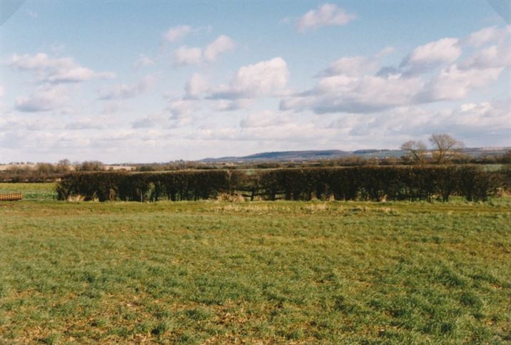
Garden Lane.
We have an isolated reference in the Wadkin collection to Garden Lane (Images, below) but no reference on a map has been found.
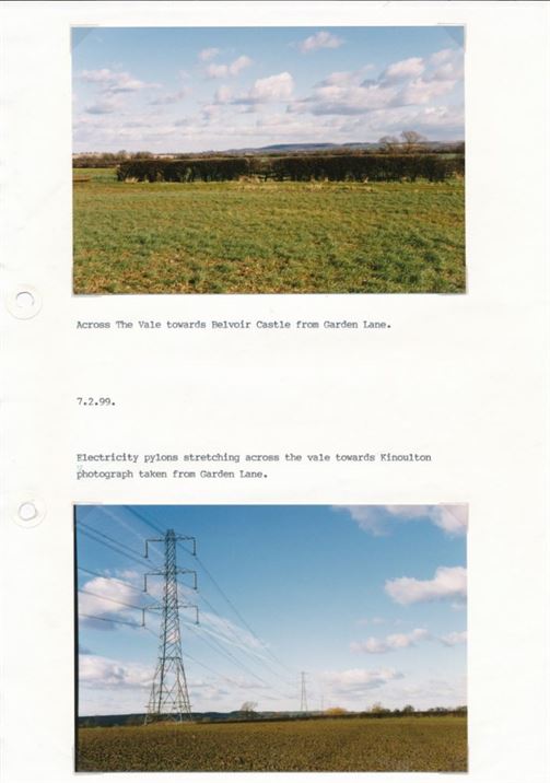
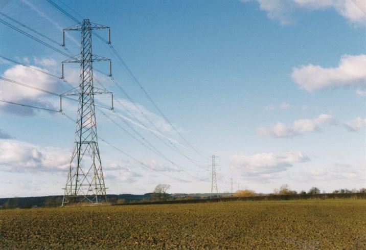
Green Lane leaves Main Street at the south end of the village, climbing the Belvoir escarpment to join the Melton rd. On the 1774 Enclosure Map it is marked as Willoughby Rd but labelling for Willoughby Rd. is rather erratic – variously including Long Lane as well as Green Lane and Folly Hall Lane but always heading towards Willoughby. The views across the Vale of Belvoir from Green Lane are amongst the best in the area and the wide verges remain a wildflower haven.
W0051 Bert Woolley with bull - Sycamore Lodge
W0051 Bert Woolley with bull - Sycamore Lodge
W0051a Bert Woolley with bull - Sycamore Lodge
W0051a Bert Woolley with bull - Sycamore Lodge
W0051aa Bert Woolley with bull - Sycamore Lodge
W0051aa Bert Woolley with bull - Sycamore Lodge
W0051aaa Bert Woolley with bull - Sycamore Lodge
W0051aaa Bert Woolley with bull - Sycamore Lodge
W0143 Green Lane (1996/7)
W0143 Green Lane (1996/7)
W0143a Green Lane (1996/7)
W0143a Green Lane (1996/7)
W0143aa Green Lane (1996/7)
W0143aa Green Lane (1996/7)
W0143b Green Lane (1996/7)
W0143b Green Lane (1996/7)
W0143bb Green Lane (1996/7)
W0143bb Green Lane (1996/7)
W0259 Green Lane cast iron signpost 2000
W0259 Green Lane cast iron signpost 2000
W0259a Green Lane cast iron signpost 2000
W0259a Green Lane cast iron signpost 2000
W0259aa Green Lane cast iron signpost 2000
W0259aa Green Lane cast iron signpost 2000
W0335 Meeting of the Quorn Hunt Dell Farm, Green Lane 2006
W0335 Meeting of the Quorn Hunt Dell Farm, Green Lane 2006
W0335a Meeting of the Quorn Hunt Dell Farm, Green Lane 2006
W0335a Meeting of the Quorn Hunt Dell Farm, Green Lane 2006
W0335aa Meeting of the Quorn Hunt Dell Farm, Green Lane 2006
W0335aa Meeting of the Quorn Hunt Dell Farm, Green Lane 2006
W0411a Entertainments 1895-1915
W0411a Entertainments 1895-1915
W0411b Entertainments 1895-1915
W0411b Entertainments 1895-1915
W0411c Entertainments 1895-1915
W0411c Entertainments 1895-1915
W0776 Lists of 'lane lettings for grazing' 1902 to 1929
W0776 Lists of 'lane lettings for grazing' 1902 to 1929
W0888 Green Lane farm building 2005
W0888 Green Lane farm building 2005
W0888a Green Lane farm building 2005
W0888a Green Lane farm building 2005
W0888aa Green Lane farm building 2005
W0888aa Green Lane farm building 2005
W0888b Green Lane farm building 2005
W0888b Green Lane farm building 2005
W0888bb Green Lane farm building 2005
W0888bb Green Lane farm building 2005
W0889 Green Lane View 1999 & Dell Farm barn 1999
W0889 Green Lane View 1999 & Dell Farm barn 1999
W0889a Green Lane View 1999
W0889a Green Lane View 1999
W0889aa Green Lane View 1999
W0889aa Green Lane View 1999
W0889 Green Lane Dell Farm barn 1999
W0889 Green Lane Dell Farm barn 1999
W0889bb Green Lane Dell Farm barn 1999
W0889bb Green Lane Dell Farm barn 1999
W0903 Hickling Standard 1999
W0903 Hickling Standard 1999
W0903a Hickling Standard 1999
W0903a Hickling Standard 1999
W0903b Hickling Standard 1999
W0903b Hickling Standard 1999
W0903bb Hickling Standard 1999
W0903bb Hickling Standard 1999
W0911 Vale of Belvoir from Green Lane 1976
W0911 Vale of Belvoir from Green Lane 1976
W0911a Vale of Belvoir from Green Lane 1976
W0911a Vale of Belvoir from Green Lane 1976
W0911aa Vale of Belvoir from Green Lane 1976
W0911aa Vale of Belvoir from Green Lane 1976
Wnews1 02021895to10081901 (23)
Wnews1 02021895to10081901 (23)
Wnews8 1973to04051979 (57)
Wnews8 1973to04051979 (57)
Wnews8 1973to04051979 (58)
Wnews8 1973to04051979 (58)
Wnews8 1973to04051979 (170)
Wnews8 1973to04051979 (170)
Wnews8 1973to04051979 (171)
Wnews8 1973to04051979 (171)
Wnews8 1973to04051979 (172)
Wnews8 1973to04051979 (172)
Wnews8 1973to04051979 (173)
Wnews8 1973to04051979 (173)
Wnews8 1973to04051979 (174)
Wnews8 1973to04051979 (174)
Wnews8 1973to04051979 (175)
Wnews8 1973to04051979 (175)
Hickling Pastures/Melton Road – joining the A46/Fosse Way
Hickling Pastures is a linear community of houses along the road linking Nottingham and Melton; it was the closest ‘turnpike’ road for Hickling village and would have been a major link for travel and commerce (as it still is). More work is needed to trace the development of this route as a main road but it is likely to be linked to the line of the Belvoir escarpment providing the most easily managed east to west route. Similarly, the development of houses and farms along this road is likely to be linked to the ease of travel and links to neighbouring communities.
The Fosse Way (now the A46) was originally a Roman Road and in many places retains the long, straight characteristics of Roman construction.
The line of the road (and the escarpment) marks a divide between the ‘Wolds’ landscapes and the Vale itself. If you can help us with further information on the history and development of this part of the parish, please contact us.
W0265a Widmerpool - service station (pre-1964)
W0265a Widmerpool - service station (pre-1964)
W0265bb Widmerpool - new flyover (1964)
W0265bb Widmerpool - new flyover (1964)
W0265 Widmerpool - service station (pre-1964) & new flyover (1964)
W0265 Widmerpool - service station (pre-1964) & new flyover (1964)
W0265b Widmerpool - new flyover (1964)
W0265b Widmerpool - new flyover (1964)
W0052 Wedding of Lizzie White & Ernest Shelton
W0052 Wedding of Lizzie White & Ernest Shelton
W0052a Wedding of Lizzie White & Ernest Shelton
W0052a Wedding of Lizzie White & Ernest Shelton
W0052aa Wedding of Lizzie White & Ernest Shelton
W0052aa Wedding of Lizzie White & Ernest Shelton
W0264 Hollingworth's Cattle Transport (1940s)
W0264 Hollingworth's Cattle Transport (1940s)
W0264a Hollingworth's Cattle Transport (1940s)
W0264a Hollingworth's Cattle Transport (1940s)
W0264aa Hollingworth's Cattle Transport (1940s)
W0264aa Hollingworth's Cattle Transport (1940s)
W0264b Hollingworth's Cattle Transport (1940s)
W0264b Hollingworth's Cattle Transport (1940s)
W0264bb Hollingworth's Cattle Transport (1940s)
W0264bb Hollingworth's Cattle Transport (1940s)
W0264c Hollingworth's Cattle Transport (1940s)
W0264c Hollingworth's Cattle Transport (1940s)
W0264cc Hollingworth's Cattle Transport (1940s)
W0264cc Hollingworth's Cattle Transport (1940s)
W0776 Lists of 'lane lettings for grazing' 1902 to 1929
W0776 Lists of 'lane lettings for grazing' 1902 to 1929
Kinoulton Lane.
As the name implies, this is the road out of Hickling and towards Kinoulton; unsurprisingly, the road is called ‘Hickling Lane’ as it emerges from Kinoulton and towards Hickling. The 1774 Enclosure Map simply reads, ‘Road from Kinoulton’.
W0063a Kinoulton rd. (JL Laws sketch & snow)
W0063a Kinoulton rd. (JL Laws sketch & snow)
W0063bb Kinoulton rd. (JL Laws sketch & snow)
W0063bb Kinoulton rd. (JL Laws sketch & snow)
W0063 Kinoulton rd. (JL Laws sketch & snow)
W0063 Kinoulton rd. (JL Laws sketch & snow)
W0063b Kinoulton rd. (JL Laws sketch & snow)
W0063b Kinoulton rd. (JL Laws sketch & snow)
W0115 Bridge Farm fields before bungalows built (1960s)
W0115 Bridge Farm fields before bungalows built (1960s)
W0115a Bridge Farm fields before bungalows built (1960s)
W0115a Bridge Farm fields before bungalows built (1960s)
W0115aa Bridge Farm fields before bungalows built (1960s)
W0115aa Bridge Farm fields before bungalows built (1960s)
W0254 new main sewers being laid 1993
W0254 new main sewers being laid 1993
W0254a new main sewers being laid 1993
W0254a new main sewers being laid 1993
W0254aa new main sewers being laid 1993
W0254aa new main sewers being laid 1993
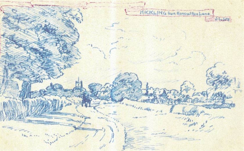
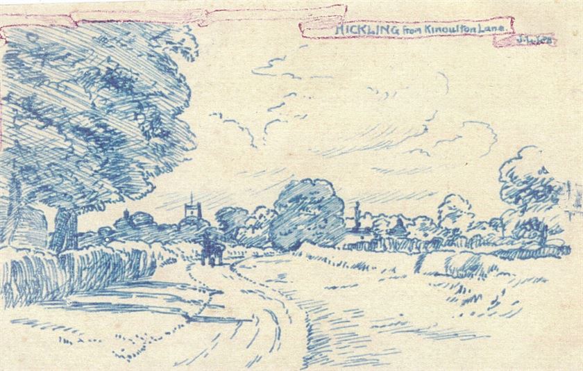
W0766 2 drawings by Mr Laws Kinoulton Lane and the Mill
W0766 2 drawings by Mr Laws Kinoulton Lane and the Mill
W0766a drawing by Mr Laws Kinoulton Lane
W0766a drawing by Mr Laws Kinoulton Lane
Wnews2 17081901to06071907 (45)
Wnews2 17081901to06071907 (45)
Wnews8 1973to04051979 (10)
Wnews8 1973to04051979 (10)
Wnews8 1973to04051979 (9)
Wnews8 1973to04051979 (9)
Long Lane.
Running parallel to Green Lane and Bridegate Lane, Long Lane is now a simple track and then footpath leading up to the Hickling Standard. It is shown but not named on the 1774 Enclosure Map and although Green Lane is labelled ‘Willoughby Road’ at this time, Long Lane can be seen to extend into what is labelled as ‘a footway from Willoughby’. Labelling and referencing of Willoughby Road is erratic and this may explain the belief that Long Lane extended as far as Willoughby and/or formed a section of Willoughby Rd. Either way, Long Lane is a historical track linking to what is now Folly Hall Lane and which then extended to Roman settlements at Six Hills and then to Willoughby.
In response to a national exercise, the Parish Council included Long Lane in its listings of public rights of way in the 1950s thus formalising it as a public footpath.
Thomas Burnett (1826-1921)
Thomas Burnett (1826-1921)
W0024 Thomas Burnett
W0024 Thomas Burnett
W0024a Thomas Burnett
W0024a Thomas Burnett
W0024aa Thomas Burnett
W0024aa Thomas Burnett
W0021 Harrison Thomas
W0021 Harrison Thomas
W0021a Harrison Thomas
W0021a Harrison Thomas
W0022 Marriott Chaplin Edrich
W0022 Marriott Chaplin Edrich
W0022a Marriott Chaplin Edrich
W0022a Marriott Chaplin Edrich
W0022b Marriott Chaplin Edrich
W0022b Marriott Chaplin Edrich
W0154 village trades and services
W0154 village trades and services
W0207 Post & Paper deliveries (1986)
W0207 Post & Paper deliveries (1986)
W0207a Post & Paper deliveries (1986)
W0207a Post & Paper deliveries (1986)
W0207aa Post & Paper deliveries (1986)
W0207aa Post & Paper deliveries (1986)
W0207b Post & Paper deliveries (1986)
W0207b Post & Paper deliveries (1986)
W0207bb Post & Paper deliveries (1986)
W0207bb Post & Paper deliveries (1986)
W0207c Post & Paper deliveries (1986)
W0207c Post & Paper deliveries (1986)
W0207cc Post & Paper deliveries (1986)
W0207cc Post & Paper deliveries (1986)
W0227a Village Businesses: Burnetts inc. family tree
W0227a Village Businesses: Burnetts inc. family tree
W0227b Village Businesses: Burnetts inc. family tree
W0227b Village Businesses: Burnetts inc. family tree
W0227c Village Businesses: Burnetts inc. family tree
W0227c Village Businesses: Burnetts inc. family tree
Hickling’s Main Street runs from north to south and the village settlement is very much characterised by its linear nature; so much so that modern heritage protections such as the Conservation Area designation focus specifically on this linear form with views in and out of the surrounding countryside.
W0064b Canal Basin & Bridge c.1905
W0064b Canal Basin & Bridge c.1905
W0064bb Canal Basin & Bridge c.1905
W0064bb Canal Basin & Bridge c.1905
W0064 Canal Basin & Bridge c.1905
W0064 Canal Basin & Bridge c.1905
W0064a Canal Basin & Bridge c.1905
W0064a Canal Basin & Bridge c.1905
W0064aa Canal Basin & Bridge c.1905
W0064aa Canal Basin & Bridge c.1905
W0065 View south from the bridge 1952
W0065 View south from the bridge 1952
W0067 Main St towards canal (late 1940s/early 1950s)
W0067 Main St towards canal (late 1940s/early 1950s)
W0067a Main St towards canal (late 1940s/early 1950s)
W0067a Main St towards canal (late 1940s/early 1950s)
W0067aa Main St towards canal (late 1940s/early 1950s)
W0067aa Main St towards canal (late 1940s/early 1950s)
W0070 Ivy House and Greengates
W0070 Ivy House and Greengates
W0070a Ivy House (date unknown)
W0070a Ivy House (date unknown)
W0070b Greengates 1964
W0070b Greengates 1964
W0071 Main St in the snow (1979 & 1997)
W0071 Main St in the snow (1979 & 1997)
W0071a Main St in the snow (1979)
W0071a Main St in the snow (1979)
W0071aa Main St in the snow (1979)
W0071aa Main St in the snow (1979)
W0071b Main St in the snow (1997)
W0071b Main St in the snow (1997)
W0072 (1950s) Elm Farm, Yew Tree House, Rose Cottage
W0072 (1950s) Elm Farm, Yew Tree House, Rose Cottage
W0072a (1950s) Elm Farm, Yew Tree House, Rose Cottage
W0072a (1950s) Elm Farm, Yew Tree House, Rose Cottage
W0072aa (1950s) Elm Farm, Yew Tree House, Rose Cottage
W0072aa (1950s) Elm Farm, Yew Tree House, Rose Cottage
W0072b (1950s) Elm Farm, Yew Tree House, Rose Cottage
W0072b (1950s) Elm Farm, Yew Tree House, Rose Cottage
W0073 Main St towards Church (1920s)
W0073 Main St towards Church (1920s)
W0073a Main St towards Church (1920s)
W0073a Main St towards Church (1920s)
W0073aa Main St towards Church (1920s)
W0073aa Main St towards Church (1920s)
W0073b Main St towards Church (1920s)
W0073b Main St towards Church (1920s)
W0073bb Main St towards Church (1920s)
W0073bb Main St towards Church (1920s)
W0085 Flooding - Main St 1954 & 1968
W0085 Flooding - Main St 1954 & 1968
W0085a Flooding - Main St 1954
W0085a Flooding - Main St 1954
W0085aa Flooding - Main St 1954
W0085aa Flooding - Main St 1954
W0085b Flooding - Main St 1954
W0085b Flooding - Main St 1954
W0085bb Flooding - Main St 1954
W0085bb Flooding - Main St 1954
W0085c Flooding - Main St 1968
W0085c Flooding - Main St 1968
W0085cc Flooding - Main St 1968
W0085cc Flooding - Main St 1968
W0085d Flooding - Main St 1968
W0085d Flooding - Main St 1968
W0085dd Flooding - Main St
W0085dd Flooding - Main St
W0087 Flooding - Main St 2001
W0087 Flooding - Main St 2001
W0087a Flooding - Main St 2001
W0087a Flooding - Main St 2001
W0087b Flooding - Main St 2001
W0087b Flooding - Main St 2001
W0087bb Flooding - Main St 2001
W0087bb Flooding - Main St 2001
W0088 Flooding - Main St 1975
W0088 Flooding - Main St 1975
W0088a Flooding - Main St 1975
W0088a Flooding - Main St 1975
W0088b Flooding - Main St 1975
W0088b Flooding - Main St 1975
W0088c Flooding - Main St 1975
W0088c Flooding - Main St 1975
W0088d Flooding - Main St 1975
W0088d Flooding - Main St 1975
W0101 Flooding - Main St Elm Farm 1983
W0101 Flooding - Main St Elm Farm 1983
W0101a Flooding - Main St Elm Farm 1983
W0101a Flooding - Main St Elm Farm 1983
W0101aa Flooding - Main St Elm Farm 1983
W0101aa Flooding - Main St Elm Farm 1983
W0102 Flooding - Main St 2001
W0102 Flooding - Main St 2001
W0102a Flooding - Main St 2001
W0102a Flooding - Main St 2001
W0102b Flooding - Main St 2001
W0102b Flooding - Main St 2001
W0119 Wharf & Main St (1999)
W0119 Wharf & Main St (1999)
W0119a Wharf & Main St (1999)
W0119a Wharf & Main St (1999)
W0121 Main St towards canal (1999)
W0121 Main St towards canal (1999)
W0121a Main St towards canal (1999)
W0121a Main St towards canal (1999)
W0121b Main St towards canal (1999)
W0121b Main St towards canal (1999)
W0122 Cows on Main St (1996)
W0122 Cows on Main St (1996)
W0122a Cows on Main St (1996)
W0122a Cows on Main St (1996)
W0122aa Cows on Main St (1996)
W0122aa Cows on Main St (1996)
W0124 Glebe Cottage, Church Gates, Church (1956 & 1965)
W0124 Glebe Cottage, Church Gates, Church (1956 & 1965)
W0124a Glebe Cottage, Church Gates, Church (1956)
W0124a Glebe Cottage, Church Gates, Church (1956)
W0124aa Glebe Cottage, Church Gates, Church (1956)
W0124aa Glebe Cottage, Church Gates, Church (1956)
W0124b Glebe Cottage, Church Gates, Church (1965)
W0124b Glebe Cottage, Church Gates, Church (1965)
W0124bb Glebe Cottage, Church Gates, Church (1965)
W0124bb Glebe Cottage, Church Gates, Church (1965)
W0125 Main St & Church (1987)
W0125 Main St & Church (1987)
W0125a Main St & Church (1987)
W0125a Main St & Church (1987)
W0126 Elm Farm, Yew Tree Hse, Main St. (1956 & 2003)
W0126 Elm Farm, Yew Tree Hse, Main St. (1956 & 2003)
W0126a Elm Farm, Yew Tree Hse, Main St. (1956)
W0126a Elm Farm, Yew Tree Hse, Main St. (1956)
W0126b Elm Farm, Yew Tree Hse, Main St. (2003)
W0126b Elm Farm, Yew Tree Hse, Main St. (2003)
W0127 Kynance Hse, Main St (& gypsy caravan) 1975&6
W0127 Kynance Hse, Main St (& gypsy caravan) 1975&6
W0127a Kynance Hse, Main St. (1975)
W0127a Kynance Hse, Main St. (1975)
W0127aa Kynance Hse, Main St. (1975)
W0127aa Kynance Hse, Main St. (1975)
W0127b Kynance Hse, Main St. (1976) & gypsy caravan
W0127b Kynance Hse, Main St. (1976) & gypsy caravan
W0127bb Kynance Hse, Main St. (1976) & gypsy caravan
W0127bb Kynance Hse, Main St. (1976) & gypsy caravan
W0128 Main St. towards Church (2001 & 1989)
W0128 Main St. towards Church (2001 & 1989)
W0128a Main St. towards Church (2001)
W0128a Main St. towards Church (2001)
W0128b Main St. towards Church (1989)
W0128b Main St. towards Church (1989)
W0129 Main St. horse & caravan (2002)
W0129 Main St. horse & caravan (2002)
W0129a Main St. horse & caravan (2002)
W0129a Main St. horse & caravan (2002)
W0129aa Main St. horse & caravan (2002)
W0129aa Main St. horse & caravan (2002)
W0184 Village Businesses: milk deliveries
W0184 Village Businesses: milk deliveries
W0184b Village Businesses: milk deliveries
W0184b Village Businesses: milk deliveries
W0184bb Village Businesses: milk deliveries
W0184bb Village Businesses: milk deliveries
W0190 Village Businesses: butchers - Doubleday & Simpson
W0190 Village Businesses: butchers - Doubleday & Simpson
The southern section of Main Street is more densely built and populated but retains the same essential characteristics described above. It includes, The Green which clusters behind the section where the Village Hall (previously the School) now stands; what is thought to be the oldest surviving building, Bowling Green Cottage, is located here.
W0075a Chestnut Farm (1920s)
W0075a Chestnut Farm (1920s)
W0075aa Chestnut Farm (1920s)
W0075aa Chestnut Farm (1920s)
W0075 Chestnut Farm (1920s)
W0075 Chestnut Farm (1920s)
W0075b Chestnut Farm (1920s)
W0075b Chestnut Farm (1920s)
W0075bb Chestnut Farm (1920s)
W0075bb Chestnut Farm (1920s)
W0077 Main St & School
W0077 Main St & School
W0077a Main St & School
W0077a Main St & School
W0077aa Main St & School
W0077aa Main St & School
W0077b Main St & School
W0077b Main St & School
W0077bb Main St & School
W0077bb Main St & School
W0077c Main St & School
W0077c Main St & School
W0077cc Main St & School
W0077cc Main St & School
W0138 Clawson Lane junction (1920s & 2005)
W0138 Clawson Lane junction (1920s & 2005)
W0138a Clawson Lane junction (1920s)
W0138a Clawson Lane junction (1920s)
W0138aa Clawson Lane junction (1920s)
W0138aa Clawson Lane junction (1920s)
W0138b Clawson Lane junction (2005)
W0138b Clawson Lane junction (2005)
W0138bb Clawson Lane junction (2005)
W0138bb Clawson Lane junction (2005)
W0140 Harles Acres (1990 & 2002)
W0140 Harles Acres (1990 & 2002)
W0140a Harles Acres (1990)
W0140a Harles Acres (1990)
W0140aa Harles Acres (1990)
W0140aa Harles Acres (1990)
W0140b Harles Acres (2002)
W0140b Harles Acres (2002)
W0140bb Harles Acres (2002)
W0140bb Harles Acres (2002)
W0142 Main St. from Nether Broughton/south
W0142 Main St. from Nether Broughton/south
W0142a Main St. from Nether Broughton/south
W0142a Main St. from Nether Broughton/south
W0204 Post Office/Cobblestones 1907
W0204 Post Office/Cobblestones 1907
W0204a Post Office/Cobblestones 1907
W0204a Post Office/Cobblestones 1907
W0204aa Post Office/Cobblestones 1907
W0204aa Post Office/Cobblestones 1907
W0207 Post & Paper deliveries (1986)
W0207 Post & Paper deliveries (1986)
W0207b Post & Paper deliveries (1986)
W0207b Post & Paper deliveries (1986)
W0207bb Post & Paper deliveries (1986)
W0207bb Post & Paper deliveries (1986)
W0256 new main sewers being laid 1993
W0256 new main sewers being laid 1993
W0256a new main sewers being laid 1993
W0256a new main sewers being laid 1993
W0256aa new main sewers being laid 1993
W0256aa new main sewers being laid 1993
W0256b new main sewers being laid 1993
W0256b new main sewers being laid 1993
W0256bb new main sewers being laid 1993
W0256bb new main sewers being laid 1993
W0280 Hickling School pre-1921
W0280 Hickling School pre-1921
W0280a Hickling School pre-1921
W0280a Hickling School pre-1921
W0280aa Hickling School pre-1921
W0280aa Hickling School pre-1921
W0280b Hickling School pre-1921
W0280b Hickling School pre-1921
W0280bb Hickling School pre-1921
W0280bb Hickling School pre-1921
W0576 The Post Office/Cobblestones
W0576 The Post Office/Cobblestones
W0576a The Post Office/Cobblestones
W0576a The Post Office/Cobblestones
W0576a 1907
W0576a 1907
W0577 The Post Office/Cobblestones
W0577 The Post Office/Cobblestones
W0577a The Post Office/Cobblestones
W0577a The Post Office/Cobblestones
W0582 Chestnut Farm towards Clawson Lane (early 1900s)
W0582 Chestnut Farm towards Clawson Lane (early 1900s)
W0582a Chestnut Farm towards Clawson Lane (early 1900s)
W0582a Chestnut Farm towards Clawson Lane (early 1900s)
W0583 Chestnut Farm towards Clawson Lane (early 1900s)
W0583 Chestnut Farm towards Clawson Lane (early 1900s)
W0583a Chestnut Farm towards Clawson Lane (early 1900s)
W0583a Chestnut Farm towards Clawson Lane (early 1900s)
W0584 Chestnut Farm towards Clawson Lane (early 1900s)
W0584 Chestnut Farm towards Clawson Lane (early 1900s)
W0584a Chestnut Farm towards Clawson Lane (early 1900s)
W0584a Chestnut Farm towards Clawson Lane (early 1900s)
W0658 Chestnut Farm & the Chapel (1920s)
W0658 Chestnut Farm & the Chapel (1920s)
W0658a Chestnut Farm & the Chapel (1920s)
W0658a Chestnut Farm & the Chapel (1920s)
W0660 School & Main St (1920s)
W0660 School & Main St (1920s)
W0660a School & Main St (1920s)
W0660a School & Main St (1920s)
W1302 Cromwell House (pre-1948)
W1302 Cromwell House (pre-1948)
W1302a Cromwell House (pre-1948)
W1302a Cromwell House (pre-1948)
W1302aa Cromwell House (pre-1948)
W1302aa Cromwell House (pre-1948)
W1302b Cromwell House (pre-1948)
W1302b Cromwell House (pre-1948)
W1302bb Cromwell House (pre-1948)
W1302bb Cromwell House (pre-1948)
W1303 Westholme (pre-1966)
W1303 Westholme (pre-1966)
W1303a Westholme (pre-1966)
W1303a Westholme (pre-1966)
W1303b Westholme (pre-1966)
W1303b Westholme (pre-1966)
W1303bb Westholme (pre-1966)
W1303bb Westholme (pre-1966)
W1309 The Chapel pre & post-1910
W1309 The Chapel pre & post-1910
W1309a The Chapel pre-1910
W1309a The Chapel pre-1910
W1309aa The Chapel pre-1910
W1309aa The Chapel pre-1910
W1309b The Chapel post-1910
W1309b The Chapel post-1910
W1309bb The Chapel post-1910
W1309bb The Chapel post-1910
W1309 1908
W1309 1908
W1309 1908
W1309 1908
W1313 Post Office & Main St (1907) The Plough Inn (pre-1918)
W1313 Post Office & Main St (1907) The Plough Inn (pre-1918)
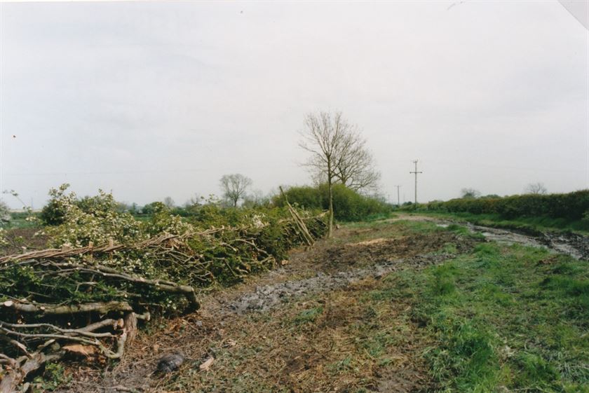
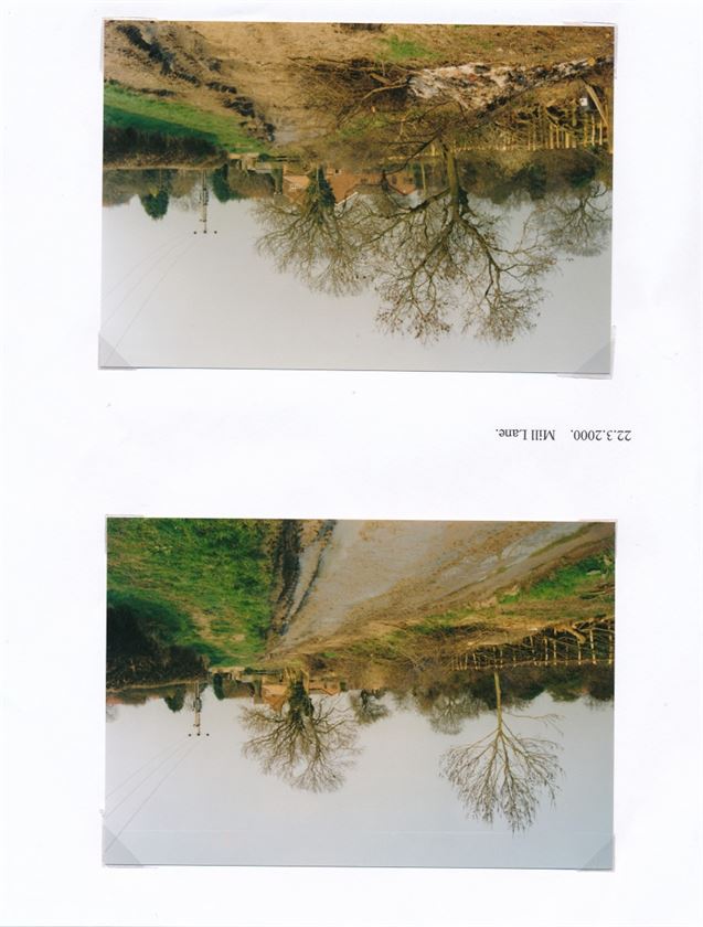
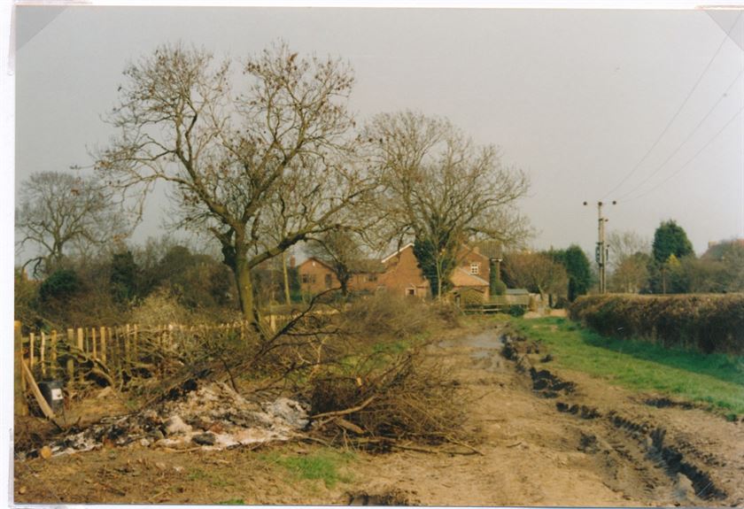
Although Mill Lane is now named after the Mill which once stood where it now ends, it originally extended further east than the mill (see Enclosure Map 1774). In land law, Mill Lane is an interesting anomaly; it is neither owned nor is it a public right of way. It originally evolved as a track which allowed access to otherwise landlocked fields and it would have emerged over time for the convenience of the owners of property and fields along its length. At the time of the Enclosures such tracks were intentionally left outside of anyone’s ownership, allowing them to continue under an amicable arrangement based on mutual convenience. Since the enclosures Mill Lane has never acquired any public rights or fallen under any one individual’s ownership – a rare and interesting relic from the past which continues to work perfectly well.
The earliest reference that we have (so far) to Mill Lane is a reference to ‘William Daft at Mawkin Lane’ in the 1642 Protestation Returns. If you can help us to identify the origin of Mill Lane’s previous names, please contact us.
W0024a Thomas Burnett
W0024a Thomas Burnett
W0024aa Thomas Burnett
W0024aa Thomas Burnett
W0024 Thomas Burnett
W0024 Thomas Burnett
W0068 Mill Lane sign & postbox July 2005
W0068 Mill Lane sign & postbox July 2005
W0068a Mill Lane sign & postbox July 2005
W0068a Mill Lane sign & postbox July 2005
W0068aa Mill Lane sign & postbox July 2005
W0068aa Mill Lane sign & postbox July 2005
W0069 Mill Lane Cottages 1962
W0069 Mill Lane Cottages 1962
W0069a Mill Lane Cottages 1962
W0069a Mill Lane Cottages 1962
W0069aa Mill Lane Cottages 1962
W0069aa Mill Lane Cottages 1962
W0069b Mill Lane Cottages 1962
W0069b Mill Lane Cottages 1962
W0069bb Mill Lane Cottages 1962
W0069bb Mill Lane Cottages 1962
W0206b Post deliveries 1970s
W0206b Post deliveries 1970s
W0206bb Post deliveries 1970s
W0206bb Post deliveries 1970s
W0227a Village Businesses: Burnetts inc. family tree
W0227a Village Businesses: Burnetts inc. family tree
W0227b Village Businesses: Burnetts inc. family tree
W0227b Village Businesses: Burnetts inc. family tree
W0227c Village Businesses: Burnetts inc. family tree
W0227c Village Businesses: Burnetts inc. family tree
W0230 Village Businesses: Burnett's woodyard
W0230 Village Businesses: Burnett's woodyard
W0230a Village Businesses: Burnett's woodyard
W0230a Village Businesses: Burnett's woodyard
W0230aa Village Businesses: Burnett's woodyard
W0230aa Village Businesses: Burnett's woodyard
W1132 Mill Lane junction (2002)
W1132 Mill Lane junction (2002)
W1132a Mill Lane junction (2002)
W1132a Mill Lane junction (2002)
W1301 Windmill, Mill Lane (1903) & Main St (date?)
W1301 Windmill, Mill Lane (1903) & Main St (date?)
W1301a Windmill, Mill Lane (1903)
W1301a Windmill, Mill Lane (1903)
W1301aa Windmill, Mill Lane (1903)
W1301aa Windmill, Mill Lane (1903)
Wnews8 1973to04051979 (9)
Wnews8 1973to04051979 (9)
Wnews8 1973to04051979 (10)
Wnews8 1973to04051979 (10)
Wnews8 1973to04051979 (117)
Wnews8 1973to04051979 (117)
Wnews8 1973to04051979 (118)
Wnews8 1973to04051979 (118)
Wnews8 1973to04051979 (119)
Wnews8 1973to04051979 (119)
Wnews8 1973to04051979 (120)
Wnews8 1973to04051979 (120)
Wnews8 1973to04051979 (121)
Wnews8 1973to04051979 (121)
Wnews8 1973to04051979 (122)
Wnews8 1973to04051979 (122)
Wnews8 1973to04051979 (123)
Wnews8 1973to04051979 (123)
Wnews8 1973to04051979 (199)
Wnews8 1973to04051979 (199)
Wnews14 30041982to06101982 (22)
Wnews14 30041982to06101982 (22)
Nether Broughton Lane.
Nether Broughton Lane begins where Main Street ends at the south end of the village and, unsurprisingly, it is the road which links Hickling and Nether Broughton; beyond the junction with Green Lane it is largely single track.
W0142a Main St. from Nether Broughton/south
W0142a Main St. from Nether Broughton/south
W0142 Main St. from Nether Broughton/south
W0142 Main St. from Nether Broughton/south
W0080 Snow 1979
W0080 Snow 1979
W0080a Snow 1979
W0080a Snow 1979
W0080aa Snow 1979
W0080aa Snow 1979
W0080b Snow 1979
W0080b Snow 1979
W0080bb Snow 1979
W0080bb Snow 1979
Pudding Lane/Faulks Lane/Mucky Lane.
We would welcome information that would help us with the various names for this short farm lane at the south end of the village.
The earliest reference that we have, to date, is in 1717 followed by the Will of George Mann in 1731; who is ‘of Pudding Lane’ when he leaves the Homestead to his two sons.
The lane is shown, but not named, on the 1774 Enclosure Map; transcription of the Schedule for this map is ongoing but the map does show neighbouring parcels of land in the ownership of the Mann family and it seems likely that the properties are still in the Mann family at this time and that the lane continues to be known as ‘Pudding Lane’ (research ongoing).
‘Faulks’ reflects the very close links to the Faulks family of Sycamore House/Farm in at least the late 1800s to the mid-1900s and has been widely used since.
In a Statutory Declaration dated 1906 George Faulks testifies that his father, John, had lived at (and owned the freehold of) Sycamore House on Pudding Lane for at least 30 years and that it had been owned by John’s father before that; placing the Faulks family in this location back to at least the mid-C19th. Because of the nature of this declaration it would seem that there hadn’t been any formal property transactions before this time (or that any documents had been lost).
Similarly, the lane is described as ‘Pudding Lane’ in a conveyance of 1919 to George Faulks following the death of Mrs Mary Smith (widow) and in Title Deeds dated 1930 in a transaction which also involves George Faulks; the two names (Pudding Lane and Faulks Lane) appear to have been used concurrently.
‘Mucky Lane’ is referenced once in the Wadkin collection – no further information available.
So far, we have no confirmed information about the origins of the name, ‘Pudding Lane’. However, it is possible that it has a shared origin with Pudding Lane in London which is said to have been named by the butchers of Eastcheap Market who used the lane to transport offal or ‘pudding’ to the river where it was transferred to waste barges and disposed of.
In a similar sense, ‘pudding’ was often washed or disposed of in nearby watercourses perhaps indicating a butchery or abbatoir.
‘Pudding’ in this sense goes back to the 1300s and probably comes from the Middle English with origins in the French word ‘boudin’ meaning ‘sausage’.
Several photographs from the Wadkin collection show a detached, thatched cottage on the Main Street corner of Faulks’ Lane which is no longer there; this cottage does also seem to appear on the 1774 Enclosure Map.
W0053a Emily & George Faulks Sycamore Farm
W0053a Emily & George Faulks Sycamore Farm
W0053aa Emily & George Faulks Sycamore Farm
W0053aa Emily & George Faulks Sycamore Farm
W0053 Emily & George Faulks Sycamore Farm
W0053 Emily & George Faulks Sycamore Farm
W0081 Flooding: W0081 to W0107
W0081 Flooding: W0081 to W0107
W0141 Faulks Lane, Mucky lane, Pudding Lane (2002)
W0141 Faulks Lane, Mucky lane, Pudding Lane (2002)
W0141a Faulks Lane, Mucky lane, Pudding Lane (2002)
W0141a Faulks Lane, Mucky lane, Pudding Lane (2002)
W0153 sport, seats, allotments, farming & water
W0153 sport, seats, allotments, farming & water
W0175 John Faulks WWI
W0175 John Faulks WWI
W0175a John Faulks WWI
W0175a John Faulks WWI
W0175aa John Faulks WWI
W0175aa John Faulks WWI
W0372 thatched house on Faulks' Lane
W0372 thatched house on Faulks' Lane
W0372a thatched house on Faulks' Lane
W0372a thatched house on Faulks' Lane
W0372aa thatched house on Faulks' Lane
W0372aa thatched house on Faulks' Lane
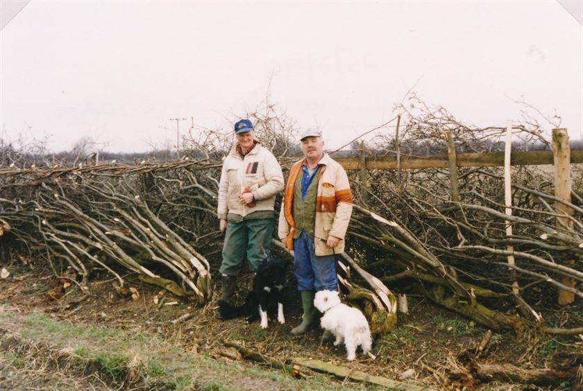
W0373 John (Jack) Parkes in Skegness
W0373 John (Jack) Parkes in Skegness
W0373a John (Jack) Parkes in Skegness
W0373a John (Jack) Parkes in Skegness
W0373aa John (Jack) Parkes in Skegness
W0373aa John (Jack) Parkes in Skegness
W0416 Football Club 1902/03 & 1938
W0416 Football Club 1902/03 & 1938
W0416a Football Club 1902/03 & 1938
W0416a Football Club 1902/03 & 1938
W0416aa Football Club 1902/03 & 1938
W0416aa Football Club 1902/03 & 1938
W0867 sheep between Harles & Faulks Lane 1998
W0867 sheep between Harles & Faulks Lane 1998
W0867a sheep between Harles & Faulks Lane 1998
W0867a sheep between Harles & Faulks Lane 1998
W0867aa sheep between Harles & Faulks Lane 1998
W0867aa sheep between Harles & Faulks Lane 1998
W0869 Sycamore Farm 1929
W0869 Sycamore Farm 1929
W0869a Sycamore Farm 1929
W0869a Sycamore Farm 1929
W0869aa Sycamore Farm 1929
W0869aa Sycamore Farm 1929
W0869b Sycamore Farm 1929
W0869b Sycamore Farm 1929
W0869bb Sycamore Farm 1929
W0869bb Sycamore Farm 1929
W0870 Sycamore Farm 1930s
W0870 Sycamore Farm 1930s
W0870a Sycamore Farm 1930s
W0870a Sycamore Farm 1930s
W0870a Sycamore Farm 1930s
W0870a Sycamore Farm 1930s
W0870b Sycamore Farm 1930s
W0870b Sycamore Farm 1930s
W0870bb Sycamore Farm 1930s
W0870bb Sycamore Farm 1930s
W1037 Faulks Lane (after 1882) - unnamed thatched house
W1037 Faulks Lane (after 1882) - unnamed thatched house
W1037a Faulks Lane (after 1882) - unnamed thatched house
W1037a Faulks Lane (after 1882) - unnamed thatched house
W1037aa Faulks Lane (after 1882) - unnamed thatched house
W1037aa Faulks Lane (after 1882) - unnamed thatched house
Washpit Lane is shown (but not named) on the 1774 Enclosure Map and on an OS Map from 1884; transcription of the Schedule for the 1774 map is ongoing and may add further detail. The only reference that we have to the use of this name is on an undated OS/Bingham Rural District Map in the Wadkin collection (images, below).
As the lane leads up to the Dalby Brook it seems a practical location for a sheep wash; unlike the washpit on Bridegate Lane it would have been used solely for animals rather than animals and vehicles. There is a photograph in the Wadkin collection of George Edson dipping sheep in the Dalby Brook close to Oak Farm and it is possible that this was the washpit indicated on the map.
")
")
")
")
")


, Washpit (2006)")
")
")
")
")
")
")
")
")
")
")
")
")
")
")
")


")
")
")


")
")

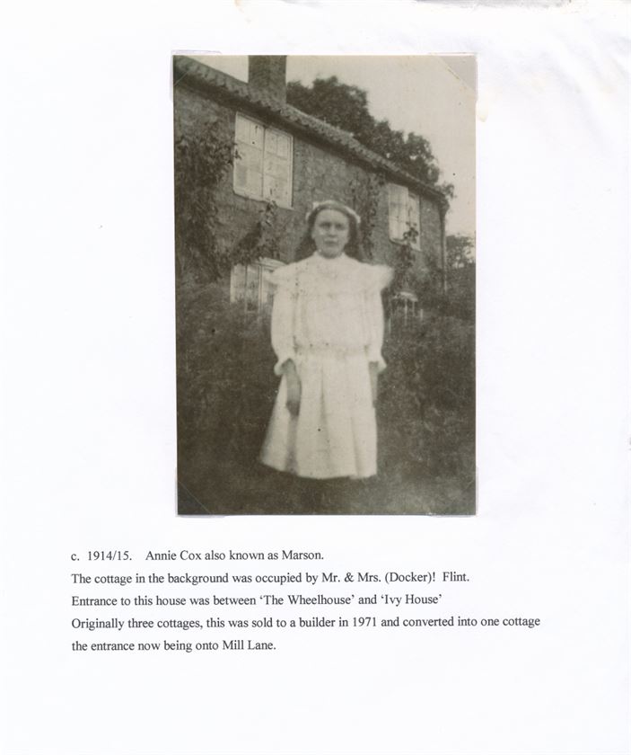
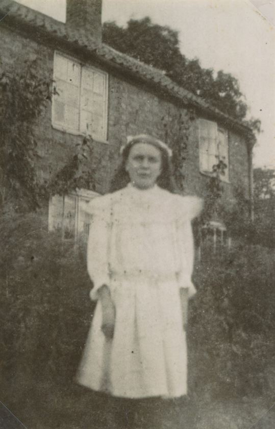
 & baby Ivy (White Cottage, Smithfield Lane pre-1963)")
 & baby Ivy (White Cottage, Smithfield Lane pre-1963)")


, Smithfield Lane 1910")
, Smithfield Lane 1910")
, Smithfield Lane 1910")
")
")
")
")


")
")
")
")
")
")
")
")
")


")
")
")
")
")
")
")
")
")
")
")
")
")
")
")
")
")
")
")
")
")
")
")
")
")
")


")
")
")
")
")
")
")
")
")
")
")
")
")
")
")
")


")
")
")
")
")
")
")
")
")
")
")
")
")
")
")
")
")
")
")
")
")
")


")
")
")
")
")


")
")
")
")
 & new flyover (1964)")
")


")
")
")
")
")
")
")
")
")
")
")
")
")
")


")
")
")
")


")
")
")
")
")
")
")


")
")
")
")
")
")


")
")
")
")
")
")
")
")
")


")
")
")

")

")
")
")
")
 Elm Farm, Yew Tree House, Rose Cottage")
 Elm Farm, Yew Tree House, Rose Cottage")
 Elm Farm, Yew Tree House, Rose Cottage")
 Elm Farm, Yew Tree House, Rose Cottage")
")
")
")
")
")


")
")
")
")
")
")
")
")
")
")
")
")
")
")
")
")
")
")
 1975&6")
")
")
 & gypsy caravan")
 & gypsy caravan")
")
")
")
")
")
")


")
")


")
")


")
")


 1997")
 1997")
 1997")

 & Main St (date?)")
")
")


")
")
")
")
")


")
")
")
")
")
")
")
")
")
")
")
")
")
")
")
")
")
")
")


 The Plough Inn (pre-1918)")
")

")


")
")
")
")
")
")


")
")


 Parkes in Skegness")
 Parkes in Skegness")
 Parkes in Skegness")


 - unnamed thatched house")
 - unnamed thatched house")
 - unnamed thatched house")


 - unmarked")
 - unmarked")
 - unmarked")
 - unmarked")
 - unmarked")
")
")
")