A few farming highlights:

")


")
")


Contents:
Farming and the Rural Landscape – a history
The landscape that is familiar to us in the early C21st has taken millennia to evolve but the most significant changes in the most recent centuries have had profound impacts on our relationship with our rural landscape; the mediaeval open field system; Enclosure; the Industrial revolution. Changes in the rural landscape that are accompanied by social change, too.
If we know what we’re looking for, traces of ancient as well as modern changes can be identified in the landscape around us; the lecture notes and book extracts on this page help us to spot these signs and also help us to understand how we arrived where we are now.
Farming – general (from the Wadkin Archives)
Margaret and Hazel Wadkin’s collections reflect their roots in the farming community and friendship with the farming families of Hickling. Hazel’s collections and books contain many photographs and recollections, so these have been uploaded to their own page: click here.
Wadkin Archive material which is specific to individual farms and families can be found in the paragraphs below and on the separate ‘house’ and ‘family’ pages. We are gradually uploading all of this material; if you are interested in material which hasn’t been uploaded yet, please contact us.
Allotments
There is evidence that allotments have been in existence as far back as the early mediaeval period; however allotments, as we know them today, are largely the product of Enclosure in the late C18th. The Enclosure of lands previously available to everyone for foraging and grazing created a new rural poor and left the Parish and the Church with the responsibility of looking after them. One way to do this was to provide allotments that would allow villagers to be more self-sufficient.
There is evidence of two large allotment areas in Hickling; but it isn’t clear when each one was first established or, indeed, when they stopped being used. Both were some way outside the village:
- Clawson Lane; this seems to have been on land held by the Rector
- Bridegate Lane; this seems to have been managed by the Parish
A snapshot can be found in the 1910 Finance Act Map and Schedule:
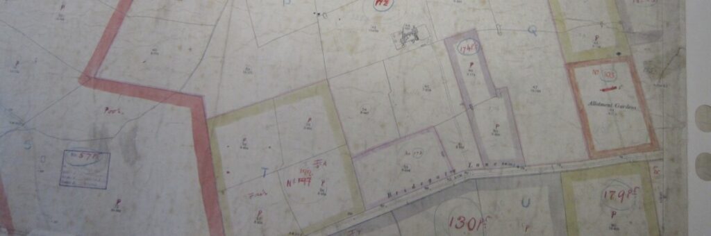
The Bridegate Lane allotments seem to be under the management of the ‘Members Old Club’ with the land owned by ‘selves’ and the secretary is listed as Thomas Clements Rose. Confusingly, the schedule states the allotments are on Long Lane, but this was where Mr Rose lived which may have led to the error.
They are just over 8 acres in size.
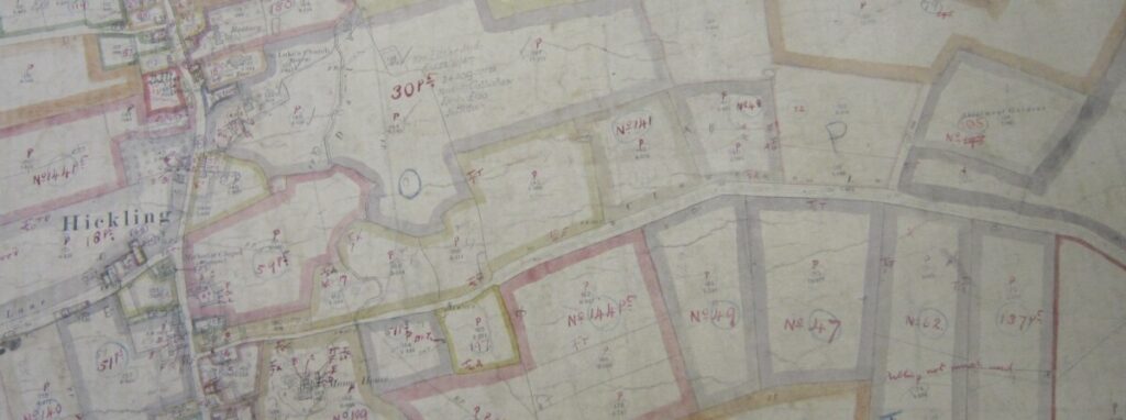
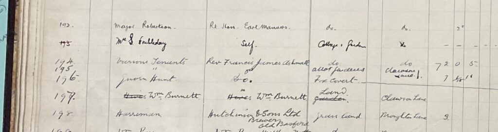
The Clawson Lane allotments are listed as allotment gardens and the land is owned by the Revd. Francis James Ashmall with various tenants.
They are listed as 7 acres in size.
Extracts from Hazel Wadkin’s Books: Allotments
Scrapbook of Hickling:
- (p.19) April 1897. The body of Emma Magson was found in the lane leading to Skelton’s allotments on Clawson Lane. There were empty carbolic acid bottles at her side and an open umbrella in her right hand. The deceased lived at Bingham but had been staying with her mother in Hickling for the week before her death.
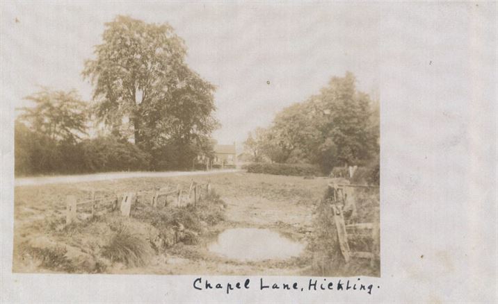
- (p.47) There were two separate fields of allotments which were rented to any parishioner. One field was known as Bridegate Gardens and was situated about half a mile up Bridgegate Lane in the field before the present cricket field. The other was down Clawson Lane and known as the Parsons Gardens. People would walk to the gardens pushing a wheelbarrow to carry their tools etc.
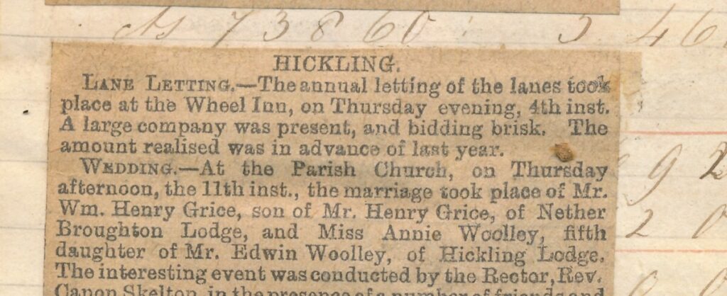
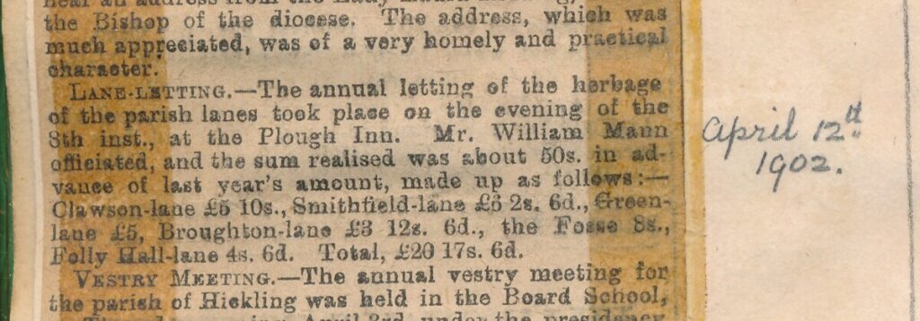
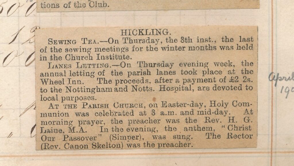
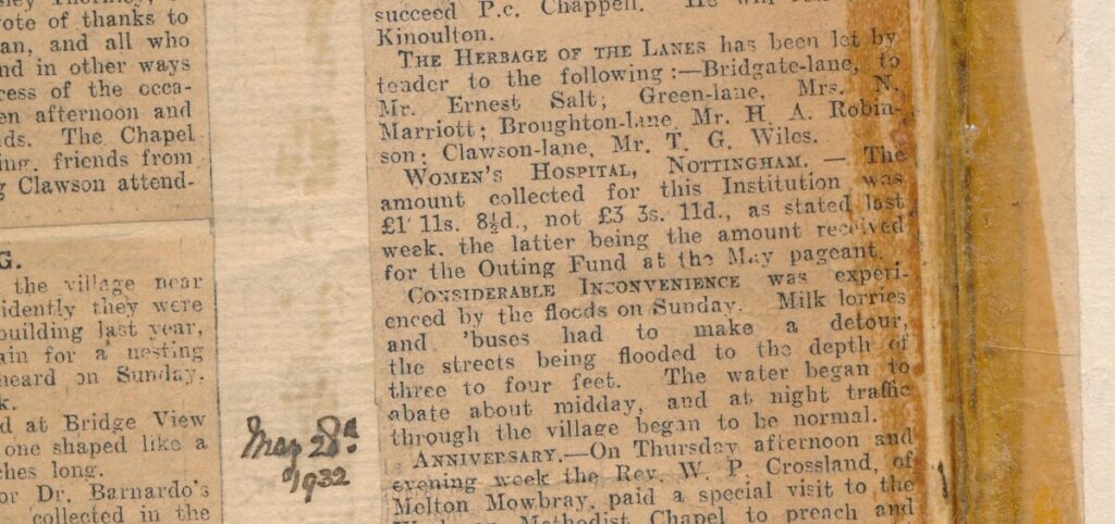
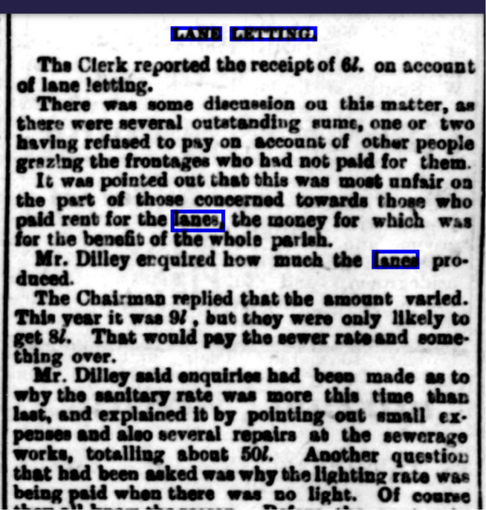
Lane Letting.
Lane Letting appears to have similar origins to the allotments; emerging as an opportunity to offer grazing of the lane verges to the rural poor and allowing them to be more self-sufficient. The verges are generally owned by the parish, and as the need for rural poor provision decreased it looks like some parishes saw an opportunity to top up their funds with these verges, or raise money for charity.
(Wadkin) Scrapbook of Hickling:
(p.67) The lanes leading out of the village were let annually [by the Parish Council] for grazing.
- April 1902 Letting took place at ‘The Plough’. Clawson Lane – £5. 10s. 0de Smithfield lane – £6. 2s. 6d. Green Lane – £5. 0s. 0d. Broughton Lane – £3. 12s . 6d. The Fosse – 8s. 0d Folly Hall Lane – 4/6d.
- April 1918 – Bridegate Lane (Mrs. A. Collishaw) £6. 15s. 0d Green lane (Mr. F. Woolley) – £3. Broughton Lane (Mr . T.G. Wiles) – £2. 10s . 0d Clawson Lane (Mr. H.W. Woolley) – £4. Waste pit garden (Mr. T.W. Jeffery) – 2/6d.
- April 1919 – Bridegate Lane (Mrs . A. L.Collishaw) – £6. 15s . 0d Green lane (Mr. F. Woolley) – £6. Broughton Lane (Mr. C Shelton) £5. 5s. 0d Clawson Lane (Mr. E. Parr) £6. Folly Hall Lane (Mr. T. Elliott) 1/-.
- April 1922 – Bridegate Lane (Mr. T.Elliott) £4. Green Lane (Mr. Noel Marriott) £4 Broughton Lane (Mr. Arthur Shelton) £4. 12s . 6d. Clawson Lane (Mr. T.G.Wiles) £4. Folly Hall Lane (Mr. T. Elliott) 1/-.
- May 1925 – Broughton Lane (Mr. J. Dickman) £1.10s.0d Clawson Lane (Mr. T.G. Wiles) 10/-. Bridegate lane (Mr. E.Salt) £4. Green Lane and Folly Hall Lane (Mrs. N. Marriott) £2. 5s. 0d and 1/-.
- April 1928 – Bridegate Lane (Mr. Job Flavell) £7. 10s. Green Lane (Mrs. Noel Marriott) 15/-. Broughton Lane (Mr. H. Robinson) 10/-. Clawson Lane (Mr. T.G. Wiles) 10/-. Folly Hall Lane (Mr. E. Scott).
- March 1929 – Bridegate Lane (Mr. D. Simpson) £6. 10s. Green Lane (Mrs. N. Marriott) £3 . 10s. Broughton lane (Mr. H Robinson) £3. 8s Clawson Lane (Mr. G.A. Faulks) £1.
The Washpit, Bridegate Lane
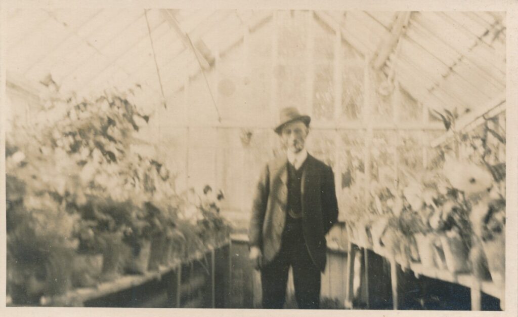
The Kerry family smallholding.
This undated photograph is believed to be of Mr Kerry who had a smallholding and greenhouses at The Butty/East End’ (now Carneal Cottage) on the corner of Mill Lane and Main Street. The family sold their produce to local markets.
The Farms:
Material which is specific to individual farms and families can be found in the paragraphs below and on the separate ‘house’ and ‘family’ pages. We are gradually uploading all of this material; if you are interested in material which hasn’t been uploaded yet, please contact us.
Information and Galleries will be added to these sections in the next few days – our apologies for the lateness! (31/10/23)
Barlands Field, Bridegate Lane
Beech House
Canal Farm
Chestnut Farm
Church Farm
Dell Farm, Green Lane
The Elms
Fox & Hounds Farm, Hickling Pastures
Hickling Lodge, Hickling Pastures
Hill Farm, Bridegate Lane
Home Farm
Lincoln Lodge, Bridegate Lane
Malt House Farm
Manor Farm, Hickling Pastures
The Manor
March Farm
Oak Farm
Rose Cottage/Simpson’s Butchers
The Ruins
Sherwood Farms/Kinoulton Grange
Sycamore Lodge, Green Lane
Waterlane Farm
AGRICULTURE.
(An Introduction by Carol Beadle, 2015)
When the Romans came they either took over or exploited what had become a well settled agricultural region. They built their town, Vernometum, by the Fosse close to Hickling Pastures and Upper Broughton Parish. The Romano-British dwellers in this area were grain producing and animal rearing farmers who provided food for themselves, for the town of Vernometum and also for the nearby cities, RATAE (Leicester) and LINDUM COLONIA (Lincoln).
The open field system developed from the late Saxon period where 2, 3 or occasionally more great open fields were farmed in rotation from nucleated settlements. These remained a dominant feature of this landscape until population changes in the C14th and C15th meant a change towards animal husbandry and the enclosure of land.
RIDGE AND FURROW
The ridge and furrow grasslands seen in this area are remnants of medieval landscapes that were set to pasture when Enclosure took place. Many ridge and furrow grasslands have been lost over recent decades with the ploughing up of the pasture land and conversion to arable. This has increased the rarity and the historic importance of the remaining ridge and furrow areas.
Where ridge and furrow survives, it’s very antiquity is an indication that the area has never been ploughed or re-seeded. These grasslands therefore have a diverse flora and a high landscape, nature and historic conservation interest and therefore should be conserved. They may also hide many archaeological treasures.
In medieval times there was a strict Manorial control over fishing and fish ponds were constructed on monastic granges such as Thurgaton Grange on the edge of Hickling Village. Fruit was also a vital crop and the manorial surveys done of the Medieval Vale lists many orchards. Nether Broughton, for example had 20. A further by-product of these trees was beekeeping, something which still continues in the area today with local honey being sold at many outlets. By the 1800s many orchards still existed. The fruit trees, especially plum and apple provided not only for the consumption of the neighbourhood but quantities were sent to the towns of Nottingham, Melton and Grantham.
‘Hickling Parish contains about 3000 acres of strong clay land which was enclosed in 1777′ (ref White Directory 1832)
‘Nearly the whole of the land is now used for grazing’ (ref Kelly 1922)
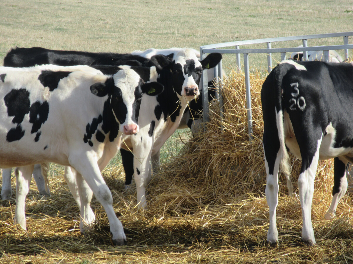
The pastoral farming in the area, with stock farming as well as Dairying is an important rural industry. Hickling is distinctive in the fact that it still has land farmed within the village. The isolated farmsteads in the area became established after enclosure.
The Vale of Belvoir has for centuries been known as a productive grazing region. The area is regarded as one of the highest quality fattening pasture land in the Midlands, serving the local meat and milk markets. The area is renowned for the manufacture of Stilton Cheese. 43 local farms supply milk to Long Clawson Dairy for Stilton Cheese production. It is a co-operative and one of the oldest farmer’s co-operatives in the country. On their website they state, ‘All of our farms are members of the Red Tractor Farm Assurance Scheme … demonstrating commitment to … environmental protection’.
Developments in agricultural technology in recent decades have led to changes in agricultural use of land in the area. Hickling Pastures now has a vineyard and hopefully soon local wine will be available.
‘The vale pastures are an intrinsic part of the region’s historic character, being closely associated with features such as small scale field patterns, old mixed hedgerows, ridge and furrow and village edges. In order to maintain the historic character of the pastures, it is important that these features are conserved’ (nottinghamshie.gov.uk).
Further reading:
NaturalEngland.org.uk
Local History in England WG Hoskins