Article No.3 by Carol Beadle
HICKLING CHURCHYARD –MORE THAN JUST GRAVESTONES
NO 3 –THE BENCHMARK
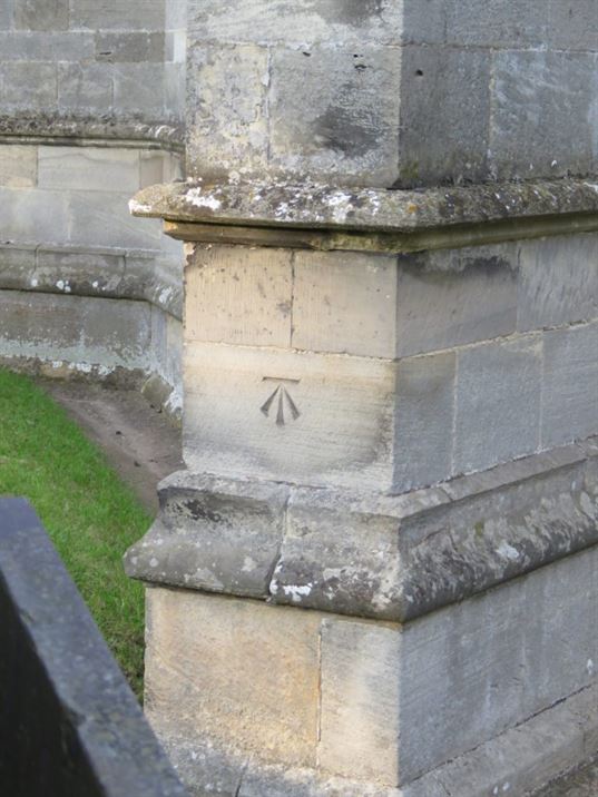
There is a benchmark etched into the outer wall of the Church near the base of the tower and to the left of the ‘Tree of Life’ stone.
The term ‘benchmark’ is sometimes also known as ‘a survey mark’. Such benchmarks are not unique and originally about 500,000 were created across Great Britain. However, with demolition and remodelling of buildings and infrastructure changes, benchmarks are becoming increasingly rare. Originally the majority of these marks were located in urban areas but those surviving are found mostly now in rural areas where there has been less; modernisation
Today, many people do not know what benchmarks are and so perhaps that is a reason they are not maintained and protected. Local planners do not seem to insist they are preserved when properties are externally changed. One benchmark on a house on Hickling Pastures disappeared entirely when the house was extended a few years ago. There is at least one other on Hickling Pastures and this is found on Sycamore Lodge, Green Lane [Dorothy & Jog Chahal’s former house]. If you know of any more benchmarks in Hickling or on the Pastures please let the History Group know.
Benchmarks started to appear in Great Britain in 1840 when ordnance survey mapping commenced. ’Benchmarks were used as a means of making ordnance maps accurate
Benchmarks traditionally are a chiselled-out arrow and a horizontal mark which the surveyors made in stone structures. The idea was that an angle iron could be placed in the horizontal mark to form a ‘bench’ for a levelling rod. This fixed horizontal line ensured that a levelling rod could be accurately repositioned in the same place in the future.
These benchmarks were fixed points which were used to calculate the height above the mean sea level. A whole systematic network of levelling lines spead across Great Britain. Most villages had about 6-8 benchmarks but towns had many more. They were etched into permanent features such as churches, nouses, bridges and even stone troughs.
If the exact height of one benchmark [BM] was known the exact height of the next could be found by measuring the difference in height through a process of spirit levelling. Subsidence, often due to mining, has affected the accuracy of the levelling values today.
Today, surveyors use GNSS [Global Navigation Satellite System] technology and what would have taken or maybe even weeks in the past, now takes just seconds.
Benchmarks remain as a nostalgic reminder of how Britain used to be mapped.